Consultation response to
Holmesdale Road & Albert Road
Healthy Neighbourhoods
Who we are
Holmesdale Community Action Group is a community group bringing neighbours together who are dedicated to making our local area a safer, cleaner, and better place to live.
Shape Better Streets is a resident campaign supporting the principle of a Low Traffic Neighbourhood in Crystal Palace and South Norwood. Our website address is: https://shapebetterstreets.org and our email address is CrystalPalaceLTN@gmail.com.
Croydon Climate Action is a group of activists who work with our local Council, businesses, schools, communities, and other green groups to help mitigate the impacts of climate change on a local level through lobbying and raising awareness of issues.
Croydon Cycling Campaign is a group of Croydon locals who want to see Croydon transformed into a city that is welcoming to cyclists of all ages and abilities. We work with the council to encourage high quality provision for cycling, organise rides and socials and campaign tirelessly for a real cycling revolution.
Croydon Living Streets is a group of volunteers working to make every day walking safer, easier, and more enjoyable across our community.
Key points
- The climate crisis, national and local policy all call for a local approach based on reducing private vehicle use and the air quality, noise, and traffic danger it creates, to make neighbourhoods safe and pleasant and encourage active travel. Recent government guidance has reinforced the importance of tackling excessive motor vehicle use and encouraging active travel.
- The Council should continue to implement and refine Healthy Neighbourhoods unless there is strong evidence that any harms significantly outweigh the benefits and cannot be mitigated by changes to the scheme.
- The two neighbourhoods featured in this response are both majority BAME, lower income neighbourhoods, with almost half of households not owning a vehicle. There are several schools in the Albert Road neighbourhood. There are therefore particularly strong equalities arguments for tackling the pollution and road danger caused by rat-running.
- The temporary changes to Holmesdale Road implemented in 2020 were a necessary response to the previous steady increase in its use as a rat-run. The volume and frequent dangerous and illegal behaviour of drivers was both harming residents and unacceptable for what is supposed to be a safe cycle route alternative to busy and dangerous nearby main roads.
- The geography of the Albert Road neighbourhood, and the longstanding modal filter in Regina Road, stopped its streets being used by through traffic. Nevertheless, the temporary measures introduced in 2020 were a justifiable response to frequent speeding and other dangerous behaviours by drivers accessing the area. Such driver behaviour was unacceptable both for residents and users of the cycle route running through the neighbourhood from Sunny Bank to Spring Lane, and on to Addiscombe and East Croydon.
Our headline response to the consultation is as follows:
- The temporary measures have been highly effective in improving the tranquillity, air quality and safety of the two neighbourhoods. However, the limited scope of the Holmesdale Road measures has left residents, and users of the Holmesdale Road cycle route, still exposed to high volumes of north-south rat-running.
- The Council should continue and build on the current restrictions to motor traffic movement in the two neighbourhoods. To abandon the schemes would once again expose both residents and cycle route users to air and noise pollution and traffic danger.
However:
- There is no need to replace the planter filters on Albert Road with ANPR. The planters are more effective in enforcing a quiet and safe neighbourhood. The minimal distances involved in diverting around the planters mean that little would be gained from ANPR in terms of emergency service or resident access.
- The experimental scheme proposed for Holmesdale Road is insufficiently ambitious. The Council should retain the current three planter locations for the time being and engage with the community on a scheme which will protect all streets in the neighbourhood from rat-running traffic. Such an ambitious scheme could well retain planter filters in more locations than the west side of Park Road.
- Through the proposed experimental period and beyond, the council needs to develop effective measures to address the safety of main roads on the edge of the two schemes, for the benefit of residents and to provide continuity for cycling routes. In particular, there is a need to improve cycle and pedestrian safety at Goat House Bridge, Spring Lane and Park Road, and address speeding and other dangerous driver behaviour on the latter. We also urge the council to work with community organisations in promoting understanding of the opportunities for cycling and walking in Healthy Neighbourhoods.
- Claims in the leaflet distributed by Open Our Roads are unsupported by evidence and in some cases completely false.
Policy context
Our December 2020 submission on the Crystal Palace and South Norwood proposals explored the global, national, and local policy context within which decisions on streets and travel should be taken. The climate crisis, the need to combat unacceptable air quality, and the safety and economic impact of traffic congestion all make it imperative that the council takes bold and decisive action to reduce motor traffic and encourage active travel. The council’s adopted plans and strategies on climate, air quality, public health and active travel all reflect this imperative. For more detail, please see our submission.
Since that submission, the policy case and evidence have continued to strengthen. On 30 July, the Department for Transport published further Network Management Duty Guidance, making clear the Government’s expectation that highway authorities would continue to prioritise improvements for active travel. The guidance, and the accompanying Ministerial letter, made it clear that councils should keep schemes in place for long enough for their success to be properly evaluated, and should use robust methods to test public opinion. It made clear that funding for active travel, and funding for transport more generally, could be withdrawn if councils abandon active travel schemes without robust evidence.
The evidence base continues to strengthen. London councils, including Lambeth. Southwark, Hackney, Enfield, and Ealing, have all published analyses of traffic which suggest healthy neighbourhood schemes do not significantly lead to worse traffic on nearby main roads. Academic research has also been published debunking false claims often made about schemes. For example, studies show that schemes of this kind tend to benefit lower income and BAME people, they do not adversely affect emergency services response times, and they are not associated with increases in street crime.[1]
The Government and others have published polling which suggests majority public support for reducing traffic and improving conditions for active travel.[2]
How the policy context should shape a decision
The weight of national, London and local policy points overwhelmingly to the need to reduce motor vehicle use and encourage active travel. It also points to the importance of creating low-traffic environments in which the air and noise pollution associated with excessive traffic is removed, and in which active travel is encouraged.
That does not, of course, justify persisting with a particular scheme if it does not achieve these objectives, or results in significant unintended adverse consequences. But it does point strongly towards only abandoning a scheme if:
- there is clear evidence that the harm outweighs the benefits;
and
- any harm cannot be addressed by modifications to the scheme.
In our view, the two South Norwood schemes:
- Have resulted in very significant benefits.
- Have caused minimal disbenefits. Claims which have been made about adverse consequences are, at best, exaggerated, and in some cases are not supported at all by the evidence.
However, the Holmesdale Road scheme, limited to filters on just one street, has not had a sufficient impact on traffic across the neighbourhood as a whole.
About the neighbourhoods
Geography
The proposed Albert Road Healthy Neighbourhood is bounded by rail lines and the Country Park to one side, and the A215 Portland Road on the other side. Vehicle movement to the east is not possible, and a longstanding modal filter in Regina Road prevents vehicle traffic from entering from or exiting to the A213 Penge Road. Before the additional filters were installed in 2020, it did not therefore experience through traffic in the fullest sense of the term. However, there was a tendency for traffic to use Albert Road, in particular, for access, rather than entering or leaving the neighbourhood via the shortest route from Portland Road. Residents experienced significant speeding and other anti-social driving behaviours.
Action to reduce traffic on Albert Road, in particular, was justified because:
- It is typically heavily parked up, and there is insufficient width for opposing vehicles to pass.
- There are two primary schools and a secondary academy in the neighbourhood. With the streets in the neighbourhood also providing access to the Croydon Arena and the Country Park, they are heavily used by children and young people.
- The limited available road width is unpleasant and hazardous for cycling when there are also high volumes of motor vehicles, some of them driven irresponsibly. Yet Albert Road (with Estcourt Road, Eldon Park, Lincoln Road and Regina Road) is a designated cycle route, which should be offering a safer and more pleasant environment for cycling than Portland Road, which is dangerous and unpleasant.
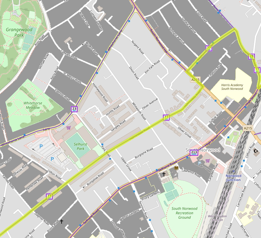
The proposed Holmesdale Road Healthy Neighbourhood is bounded by the A215 South Norwood Hill, the A213 South Norwood High Street/Selhurst Road, and the B classified Whitehorse Lane. Park Road (a borough classified road) runs through it. Before filters were installed on Holmesdale Road in 2020, streets in the neighbourhood were heavily used by rat-running drivers. Action to reduce traffic was justified because:
- Almost all streets in the neighbourhood are heavily parked up with insufficient remaining width for opposing motor vehicles to pass.
- Air and noise pollution, and traffic danger, adversely affected people living in the neighbourhood.
- Holmesdale Road is a designated cycling route which should provide a pleasant and safe alternative to Whitehorse Lane and the A213, neither of which are pleasant roads for cycling. Yet it was made unpleasant and dangerous for cycling both by traffic rat-running along it, and crossing traffic on the north-south roads.
Demography
Figure 1 shows key demographic information.[3] Both neighbourhoods have 5-6,000 inhabitants. Both are majority-minority and generally lower income neighbourhoods, with owner-occupation only at 50% or so, and within the 30% most deprived neighbourhoods in England. 40-50% of residents do not have a car.
| Population | % non-white | % car owning | %Tenants | Deprivation* | |
|---|---|---|---|---|---|
| Albert Road | 5,900 | 56 | 57 | 46% | 2-5 |
| Holmesdale Road | 5,100 | 61 | 53 | 50% | 2-5 |
Neither neighbourhood is therefore at all a “small, wealthy, white, enclave”, as opponents of LTNs often claim.
Our views on the Council’s proposals
Albert Road
The measures taken in 2020 to reduce excessive and anti-social traffic and make Albert Road and adjoining streets safer and more pleasant for active travel have been successful. While we are not aware of any formal monitoring, members of our organisations who live in and pass through the area report:
- A significant reduction in traffic, along Albert Road especially.
- A particularly significant and welcome reduction in speeding and other anti-social driving behaviour. Breaking Albert Road into sections prevents it being used to build up speed over a distance.
- More walking and cycling, supported by resident perceptions that the area is safer and more pleasant. Older people, for example, report feeling safer when they are out and about on foot, and they are therefore walking more.
We therefore support the Council’s proposals to implement an Experimental Traffic Order, retaining modal filters at the current locations.
However, we urge the Council to consider further whether it is really necessary or the best option to replace the current two sets of planters in Albert Road with ANPR filters.
The planters are an attractive feature in the streetscape. By completely preventing motor vehicle movement, they are a better means of creating complete safety from motor traffic than ANPR filters open to permit-holders, and not offering any physical obstruction to drivers willing to pass through them illegally. It is probable that drivers willing to pass through such filters by, for example, covering plates or using false registrations, would also tend to drive dangerously. Retaining fixed filters would make only a very marginal difference to emergency service access, and would not extend journey times or distances materially for residents. An experimental scheme based wholly on fixed filters would not involve the bureaucracy and potential confusion of a scheme requiring electronic permits.
Holmesdale Road
The measures put in place in 2020 have been successful, insofar as they prevent drivers from using Holmesdale Road as a through route between South Norwood Hill and Park Road, and on towards Selhurst. This has liberated residents of the street from the previous unacceptable levels of air and noise pollution, and traffic danger. It has greatly improved the safety and attractiveness of Holmesdale Road as a cycling route.
However, the 2020 measures fell far short of a full Low Traffic or Healthy Neighbourhood. They have not prevented north-south rat-running on Dixon Road, Oliver Grove, Whitworth Road and Clifton Road, streets not at all suitable for high volumes of traffic. The continued use of these streets by drivers passing through results in continued noise and air pollution, damage to parked vehicles, and disturbance from drivers getting into confrontations. It also makes the Holmesdale Road cycle route less safe than it should be, because of crossing vehicle movements, too often at high speed and disregarding junction priorities. The 2020 measures have done nothing to improve conditions on Park Road, which remains a hostile environment for walking and cycling, with no features enforcing adherence to the posted, but almost wholly disregarded, 20 mph speed limit.
In response, the Council has proposed an additional filter, on Elm Park Road. While helpful, by itself this would not stop north-south rat-running through the neighbourhood. We also have concerns about the replacement of the current planter filters on the east side of the Park Road junction, and at the Oliver Grove junction, with ANPR filters. Like the similar proposals for Albert Road, we do not see that the benefits, in terms of emergency service and resident access, would be more than marginal. Set against that, they would result in more traffic using Holmesdale Road, including drivers illegally chancing passing through the filters. A scheme without ANPR would both be safer and avoid the bureaucracy and potential confusion of ANPR.
We do not believe the current proposals are ambitious enough. They do not seem to us to go far enough towards creating a tranquil and safe environment for residents and for people cycling and walking through the neighbourhood. We therefore urge the council to leave in place, for the time being, the current filters on Holmesdale Road, and instead to engage further with residents and local organisations on a stronger design.
We suggest the following agenda items for this engagement:
- The positioning of additional filters to prevent north-south rat-running through the neighbourhood.
- Case by case, whether fixed or ANPR filters are most appropriate for each location.
- How to improve safety on Park Road, especially at the junction with Holmesdale Road, where pedestrians and cyclists need to cross.
- Whether the scheme would be better conceived as two neighbourhoods, east and west of Park Road. If the scheme does involve ANPR, an increase in resident traffic on Holmesdale Road would be mitigated by allowing drivers only to use the sections of Holmesdale Road to the east and west of Park Road respectively.
Beyond the two neighbourhoods
In this section of our response, we encourage the Council to consider how the two schemes fit into a wider strategy for active travel in Croydon and adjoining areas. The council needs to consider the improvements needed on main roads and elsewhere to link the two schemes with other schemes to provide useful corridors, and how to increase awareness of how these and other schemes make it much safer and more attractive to walk and cycle, and therefore to switch from driving for many journeys.
Despite the welcome active travel improvements implemented over the last 18 months, Croydon generally remains a poor environment for active travel. It is 23rd out of 33 London boroughs in the 2021 Healthy Streets Scorecard.[4] Before the pandemic, sustainable modes accounted for just 51% of trips, compared with 65% in a comparable outer borough, Waltham Forest. Just a third of adults walk five or more times a week, and, pitifully, just two per cent of adults cycle five or more times a week.
To improve, Croydon needs not just to implement individual Healthy Neighbourhoods and main road schemes, but consider how they fit together into a bigger picture.
So far as these two schemes are concerned, crucial issues to consider are:
- The main road crossings where these neighbourhoods join others – the crossing of South Norwood Hill between Holmesdale Road and Southern Avenue, of Goat House Bridge from Lancaster Road to Sunny Bank, and of Spring Lane from Estcourt Road to Woodside Road. (We also note above the need to make the junction of Holmesdale Road and Park Road safer.)
- Improving connections from the northeast part of the borough to the town centre. Once the planned Crystal Palace and South Norwood Healthy Neighbourhood is implemented, there will be good cycling routes away from main roads from Crystal Palace and South Norwood towards the town centre, one via Albert Road and Woodside towards Lower Addiscombe Road, and the other via Holmesdale Road. However, there remain significant “missing links”: the route from Lower Addiscombe Road to East Croydon is roundabout and not intuitive; worse, the environment for cycling southwest from Selhurst station is extremely poor: Dagnall Park, Northcote Road, Gloucester Road and Sydenham Road are all currently very unpleasant and dangerous cycling environments.
- In co-operation with Bromley Council, how to improve links between South Norwood, Elmers End, Penge and Beckenham. For different reasons, the footway tunnel from Love Lane to Marlow Road, the route through Beckenham Cemetery, and the Country Park paths are unsatisfactory, the latter if only because in parts they are under water at times in winter!
- How to increase awareness of the improved environment for walking and cycling created by the council’s recent improvements. The current programme of second-hand bike events is welcome, but knowledge of good cycling and walking routes remains very low. Our organisations would be happy to work alongside the council on this.
Local campaigning against active travel schemes
Local opponents of the two proposed schemes have distributed a thoroughly misleading leaflet. It makes five claims, none of which are correct, as we set out below:
| Claim | The Facts |
|---|---|
| “Worse air quality – caused by traffic gridlocking surrounding roads” | The claim this has been the consequence of similar schemes in Waltham Forest is completely false. The Waltham Forest schemes have reduced air pollution on 90 % of the borough’s streets without worsening it on the main roads.[5] |
| “Hours of unremitting traffic on surrounding roads” | There is no evidence the schemes currently in place in the two neighbourhoods have led to worse traffic. Heavy traffic is caused by the over-use of private cars for journeys which could be undertaken by other means. |
| “Making the lives of the elderly and less able more difficult” | People who need to use vehicles for mobility and other reasons still have access to all streets and addresses without having to pass through a filter. Older and less able people are less likely than the general population to have access to a vehicle. Their lives are made more difficult by hostile street environments, for example excessive volumes of traffic making it difficult to cross the road.[6] |
| “Local lives being put at risk” | The real safety issue is excessive traffic on minor roads not designed to carry it: Injury risk for pedestrians and cyclists is greater on minor roads than main roads.[7] Evidence from Waltham Forest and elsewhere is of no impact on emergency service response times and no increase in street crime.[8] The notion that speeding traffic makes streets safer is ludicrous. |
| “Unfair fines” | There is nothing unfair about fines for contravening clear traffic signs and road markings – especially as the council has sent out warning letters ahead of formal enforcement. |
In both neighbourhoods, there have been repeated acts of vandalism against the planters, which have, in some cases, required the council, at additional cost, to reinforce the filters. Posters put up by our supporters have been torn down. Scheme opponents have posted dishonest claims on local social media, and abused and threatened people who challenge them.[9]
References
[1] Gear Change: One year on review, Department for Transport, 30 July 2021 https://www.gov.uk/government/publications/gear-change-one-year-on-review
[2] Public attitudes towards traffic, road use and low-traffic neighbourhoods, Department for Transport, 30 July 2021
https://www.gov.uk/government/publications/public-attitudes-towards-traffic-and-road-use
[3] Derived from Ministry of Housing, Communities and Local Government, Index of Multiple Deprivation, and London Datastore, Super Output Area Population (LSOA, MSOA), London
[4] 2021 Scorecard results overview: https://www.healthystreetsscorecard.london/results/
[5] Air Quality: concentrations, exposure and attitudes in Waltham Forest, David Dajknak et al, King’s College London, p7-9
[6] Active travel and mid-life: Understanding the barriers and enablers to active travel, Centre for Ageing Better, August 2021, p15-17; Pave the Way, Transport for All, January 2021, p 47-52
[7] Motor traffic on urban minor and major roads: impacts on pedestrian and cyclist injuries, Rachel Aldred, Municipal Engineer, March 2019
[8] The Impact of Introducing a Low Traffic Neighbourhood on Fire Service Emergency Response Times, in Waltham Forest, London, Anna Goodman, Anthony Laverty and Rachel Aldred, Ideas, 2020; The Impact of Introducing a Low Traffic Neighbourhood on Street Crime, in Waltham Forest, London, Anna Goodman and Rachel Aldred, Findings, February 2021
[9] Residents concern as South Norwood’s ‘culture war’ turns toxic, Inside Croydon, 24 August 2021 https://insidecroydon.com/2021/08/24/residents-concern-as-south-norwoods-culture-war-turns-toxic/
