Satellite navigation has been a major step forward not just for motorists, but mariners and walkers too. But are there downsides to this technology and what can we do about it?
One of the accusations levelled at our LTN is that it has diverted rat-run traffic from Croydon to Bromley roads. But is this the source of the problem or rather a reflection of a deeper one?
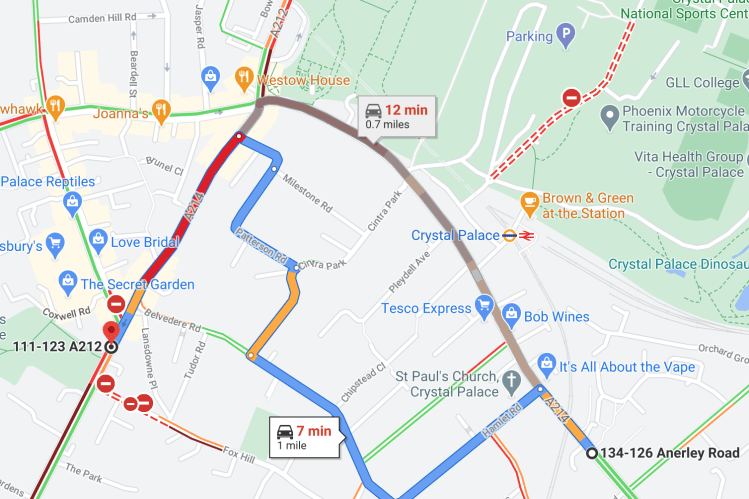
This screenshot shows Google Maps routing traffic through a warren of side streets that no-one in their right mind would follow. The algorithm saves 5 minutes but takes drivers a further 40% in distance along entirely inappropriate roads – narrow, winding, steep hills with blind bends.
The Department for Transport (& TFL) collects a wealth of traffic data that can help us understand how we have come to use the roads over time.
Over 27 years (1993-2019) motorised traffic in London has increased by a modest 18%. But if we look at residential roads (‘C’ & unclassified roads), there is a sharp rise (72%) since 2009.
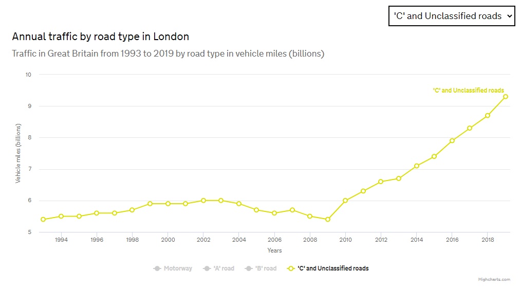
Hardly coincidentally, in 2009 Google turned to crowdsourcing to improve the accuracy of its traffic predictions. Google Maps, Waze & TomTom all continuously collect anonymised data from users’ devices to determine how fast traffic is moving. They then use this information to provide motorists with the fastest route. But should we meekly allow traffic to be routed through residential streets?
Whenever Low Traffic Neighbourhoods are introduced, some of the traffic they push out will appear elsewhere. Local traffic planning departments need to be much more proactive and devise schemes to combat this.
As Bromley councillor Angela Wilkins tweeted “21st century Catch-22: council closes off residential roads to reduce rat-running; traffic builds on main roads. So Google maps and sat nav send drivers back down residential roads to beat the jams…. methinks Bromley may have to consider some LTN road blocks of our own?”
Wouldn’t a residential filter on Belvedere Road solve the problem above?
“Main roads are for vehicles to pass through. And what has happened is we have created a road network that does not have sufficient capacity to accommodate all the cars on the network. What we have done over the decades is we have allowed our residential areas to become a kind of pressure release valve for the main roads.
Jon Burke, Hackney councillor quoted by Marcus Fairs in dezeen 25 September 2020
The answer for that problem is not to open up residential streets and allow them to accommodate even more cars. The answer is to deliver holistic approaches to reduce the overall number of cars. That shouldn’t be a radical statement.”

I thought it was a very thoroughly researched and analysed evidence based case for the rationale to support the LTN .
Excellent factual information to aid a pragmatic analysis of the traffic issue more generally.
Well done
LikeLike