Where philosophy meets cartography
Musings by Robbie Griffiths
The glorious thing about defending the concept of a Low Traffic Neighbourhood, is that it forces supporters to consider ever more aspects of human life in the city. So it was inevitable that philosophy should raise its head at some stage. So we have to thank Helen on our Facebook platform for pointing out the dangers of dogma, though I’m not sure she meant the dogma that cars and the city are somehow inevitably entwined.
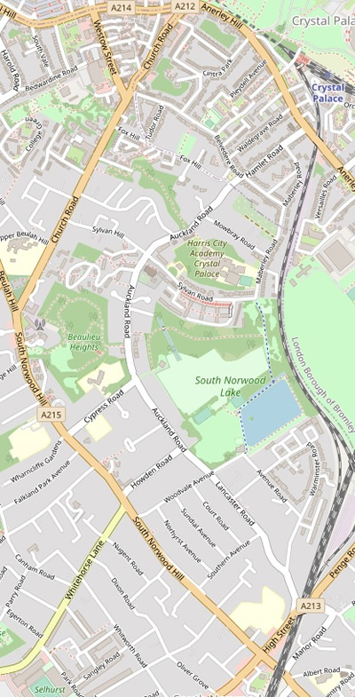
She also introduced the idea that the main roads around our LTN are not really main roads. We also have Daniel on this website arguing that Auckland Road is not really a residential road, but more akin to a main road. Is this an example of semantics, or is there a purpose behind these arguments? If there is no appreciable difference between the status of say Church Road and Auckland Road, then does the LTN have any validity?
OSM standard 
OSM ÖPNVKarte 
OSM Humanitarian 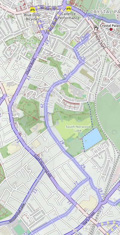
OSM cycle 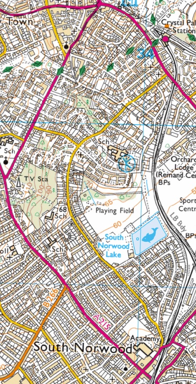
Ordnance Survey 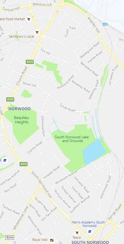
Bing
Before we examine how roads can be defined, let’s look at various maps available online. Google maps is almost unique in not revealing the class of road through colour. If we turn to Bing, we are offered in effect two options: Road or Ordnance Survey, both of which show main roads in a discrete colour. Looking further afield I stumbled upon OpenStreetMap. OpenStreetMap is built by a community of mappers that contribute and maintain data about roads, trails, cafés, railway stations, and much more, all over the world. It provides map data for thousands of web sites, mobile apps, and hardware devices. Apart from one obvious advantage of using it – it provides social as opposed to commercial data – it allows different interpretation of the underlining data by offering five layers that provide varying ways of looking at it. It is worth pointing out that in all versions that use colour to identify the class of the road, the roads around our LTN are all indicated as main roads, while some of the roads within the LTN have conflicting status.
| Map | Church Road | Auckland Road | Cypress Road | Sylvan Hill |
|---|---|---|---|---|
| Bing Street | Main | Residential | Residential | Residential |
| Bing OS | Main | Secondary | Residential | Secondary |
| OSM Std | Main | Residential | Residential | Residential |
| OSM Cycle | Main | Residential | Residential | Residential |
| OSM Transport | Obscured by bus route | Double line | Residential | Residential |
| OSM ÖPNVKarte | Obscured by bus route | Grey | Grey | Residential |
| OSM Humanitarian | Primary | Tertiary | Tertiary | Residential |
What is clear is that all cartographers agree that Church Road/Anerley Hill are main roads, while Auckland Road may have some elevated status. Cypress Road and Sylvan Hill are classed as residential by 6 out of 7 cartographers.
What is not clear is who chose the classification of these roads, what was their expertise, what was their authority?
If we now examine these roads as laypeople, what can we determine by eye or little expertise?
| Criteria | Main Roads | Auckland Road |
|---|---|---|
| Status | ‘A’ road | ‘C’ road Cycle Route 29 |
| Funded by | Central Government | Local Council |
| Lanes for moving traffic | 2 lanes for its entire length allowing cars to pass each other coming from opposite directions | For much of its length it is effectively single carriageway as vehicles are allowed to park on both sides |
| Speed limit | 30mph | 20mph |
| Speed bumps | None | Along entire length |
| Other traffic controls | Speed camera | Restricted width at council boundary; bus gate (previously) |
My verdict therefore is that our main roads, A212/A213/A214/A215 are indeed main roads according to all definitions. I would concede that they occasionally have traffic levels that overwhelms them and that levels of traffic in the Triangle don’t make it a very attractive place to visit.
The answer is not to divert this traffic onto residential roads to gain access to, at most, a tertiary road. Auckland Road has been selected to be a safe route that might encourage drivers to try out a more active form of travel and as such it is a very small step in seeking to address the problems of overuse of motorised vehicles.
If this is not the answer, then another question arises: what do we have to do to make Crystal Palace triangle a pleasant place for people? This website will be open to people who want to address the problems of 10,000 people a year dying in London due to pollution and over 2,000 people being killed or seriously injured on our streets.
What is your verdict?

It’s a simple matter of just looking at the mere geography and history. It’s a road that runs along the bottom of the natural ridge that is Church Road and South Norwood Hill. As discussed in other posts, it was one of the first roads laid in the area and for that simple fact – it was used by farm labourers, livestock and, carriages, etc. to go from Anerley to South Norwood without climbing up the hill. The geography hasn’t changed, nor has its use, of getting from an A-road at one end, to another A-road at the other end, elevating it above being a mere residential road.
The simplest counter argument to Robbie’s musings, is to invert the question: “is Auckland Road comparable to generally accept true residential roads such as Cintra Park or Mowbray Road“. The obvious answer is “no”. We can therefore agree that Auckland Road is not an A-Road, but it’s also has to be agreed that it is more substantial than a residential road. So whilst I very much am supportive of the idea of LTNs generally, I am against this Auckland Road LTN.
Had the supporters of this LTN abided by the guiding principles of LTNs, firstly they would never have chosen Auckland Road, as it is more than just a residential road and why it is getting such resistance from the community near and far. Secondly, had LTN principles been abided by, the scheme would have always included Bromley and gone up to Anerley Hill, instead of creating rat-runs from the roads that now make its periphery. Thirdly, if LTN principles had been abided by, an integrated solution would have been considered, focussed on making Auckland Road a safer shared space.
The reasons why this LTN is not going well is because it’s not an LTN, it’s just the rushed closure of the wrong roads, that has inconvenienced the majority of those living within it and definitely those living outside of it.
I’m afraid tinkering with barriers and bus gates isn’t the solution. It’s a case of rip it up and start again chaps and chapesses. Stick to the LTN principles, consult properly, produce an integrated plan.
I welcome you turning the conversation to “what do we have to do to make Crystal Palace triangle a pleasant place for people”, as I think anyone that has grown up here or chosen to move here will agree – it’s a great area that we all would like to see being enjoyed, shared and carry on thriving
LikeLike
Many thanks Daniel for opening up the conversation once again. The blog does say that Auckland Road is in an elevated status above residential road but I’m not going to go any further here (a comment on a comment on a blog!) as I think a new blog on the history of Auckland Road is impending and I will be using my trusty Anerley & Penge Ordnance Survey map of 1868 as part of my evidence and need to track down a few subsequent editions.
The LTN we are promoting on this website does have as its boundaries all the main roads. As far as I can see ‘our’ LTN does abide by all LTN principles (another blog coming) and as I am now a regular walker along Auckland Road, I can see that it is already working magnificently. Rat-run traffic has almost been eliminated and we will be doing a traffic count on Belvedere tomorrow to see whether it has in fact been diverted there. In addition, far far more people are walking and running along it, and there has been an increase in cycling.
I agree with your last sentence, and the parts of it I have come to appreciate most this year are what remains of the Great Nor Wood, in Beaulieu Heights and Stambourne Woods. Time to consider how we make the streets of the Triangle a much more pleasant place to visit!
LikeLike